General Plan
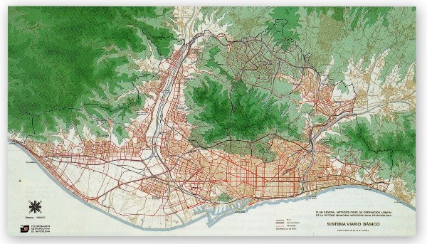 Figure [1]: Plan Comarcal 1953
Plan Comarcal
The 1953 Plan Comarcal , (County Plan) was the first general urban plan for Barcelona since the Cerda plan of 1859. It was the initial effort at planning both the metropolitan area of Barcelona, as well as the 25 adjacent cities around. The overall plan was to encourage the growth of suburbs as well as fostering the growth of garden cities in the greater area. It had green belts all over the area that were put in place for agricultural purposes, and housing units designed for a nuclear family. It had high prospects, as it appeared to address regulations on building construction, density, and zoning. While the goals were supposed to be reasonable in order to achievable, it quickly became more of a visionary document than an effective planning tool. The plan had several major shortcomings, including the lack of thought into a boom in population. This resulted in a shortage of construction and housing in appropriate districts, and neglected the shift in metropolitan population. A sudden need for housing units was needed in order to accommodate for the population growth. In 1957, the mayor was Josep Porioles, who decided to bypass the 1953 plan by approving “special development plans”. Under this project, over 300,000 units were built, all of which disregarded the basic standards and regulations that were put in place by the 1953 plan. The mayor also cut the budget for parks, culture, sports, and education to the minimum. In retrospect, it was accounted that only roughly 10% of the housing budget was spent on the construction of actual housing units, and the rest was unaccounted for, primarily due to corruption. However this cheap housing led to the development of 709,757 housing units between the years of 1955 and 1975, which accounts for a total of 69.1% of total dwellings in the city. [1]
The Aftermath
The Plan Comarcal was quickly phased out by the 1968 provincial plan, because the 1953 plan was a general plan for urban development, and didn’t provide as much help in detail towards the growth of the city. By 1960 the plans inefficacy was already noticeable, but it didn’t get phased out completely until the mid 1970s. In 1959, the plan was supplemented by the Barcelona Provincial Plan, which was to attempt at creating a more “balanced development” by redistributing industry and population. [2] The area was to be divided into 11 zones, each of which would be given individual attention, and would be worked on in terms of urban living conditions, sociological aspects of urban development, and protection of the cultural and artistic environment. The plan divided land up into categories of either use for industry or agriculture. A large flaw in the Provincial plan was that it didn’t hold any power of obligation over the legal sector, or effective legal or executive weight. In other words it created no stimulus for action, and couldn’t actually induce any change. Because it was unable to allocate resources for development, it was incapable of creating change to the basic infrastructure. A notable aim of all of the goals of the plan was decentralization, creating effective use for the entire region, but without a way to create transportation sprawl, it could not effectively pursue this idea.
In the absence of effective planning between 1950 and 1970, the regions within Barcelona quickly morphed into enormous working class blocks that completely lacked basic infrastructure or public services. Having this unplanned growth also led to segregation of social classes, and illegal settlements being put into place by poor immigrants.
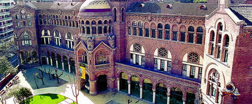 Figure[2]: Autonomous University of Barcelona
Metropolitan General Plan (GMP) of Barcelona 1976
The Metropolitan General Plan (GMP) of Barcelona was developed by Albert Serratosa, an engineer, Joan Antoni Solans, the mayor of Barcelona, and Miquel Roca Junyent, an architect. The innovations of the plan was to reduced the allowable densities of the population and reclaim land for public use by increasing urban planning efforts towards developing parks, plazas, and schools. The district of the New Ramblas reflects the effort of the GMP of 1976 in creating more open spaces and parks to consolidate the neighborhoods. Plan de Raval was opened as a public square to promote for the regeneration of the surrounding degraded areas in The New Ramblas district. The new public square attracted more pedestrians to gather in the New Ramblas district as well as more shops and businesses to move into the neighborhood. [3]
The economic crisis in Barcelona during the 1970s allowed the government to purchase a lot more land for public space development. Although half of the newly purchased land was dedicated to public facilities, citizens continued to protest because they felt like there was still a lacking in public facilities. The increasing amount of social pressure caused Mayor Solans to step down from his position. The new major, Josep Maria Socias, wished the government to be even more responsive to the demands of the neighborhoods. He purchased another 221 hectares of land for public use. One hectare of land is equal to 10,000 square meters or roughly about 2.5 acres. Socias dedicated 86 hectares of land for parks and gardens, 50 hectares for forest lands, 70 hectares for schools and other public facilities, and 15 more hectares to public housing. Many significant developments including Las Ramblas, Autonomous University of Barcelona, Laberint d'Horta Garden, and the Europa Square public housing zone were constructed under Mayor Socias's lead. [3]
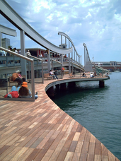 Figure[3]: The Moll de Fusta Port of Barcelona
The primary principle for developmental efforts in Barcelona during the 1980s was using public space planning as the base to build the city. Nine of the most impressive public space projects were built in Barcelona between the years of 1984 and 1992, known as the regenerating Barcelona period. Two of those public projects were the construction of the Moll de la Fusta and Las Ramblas boulevard. [3]
The Moll de Fusta is a platform that was designed on the waterfront that extended to the seafront in between the districts of Barceloneta and the southern foothills of Montjuic. The port is regarded as one of the most influential developments throughout the country of Spain; it gives a total of 300 hectares (740 acres) of land for imports as well as social gathering space for the public. The development of the port reflects one of the main goals stated on the GMP of 1976 regarding regenerating Barcelona: the conversion of ports and railways to sideways and walkways. The Moll de Fusta port continues serve as a walkway that attracts a huge amount of visitors to the city each year. [2]
The Moll de Fusta is a platform that was designed on the waterfront that extended to the seafront in between the districts of Barceloneta and the southern foothills of Montjuic. The port is regarded as one of the most influential developments throughout the country of Spain; it gives a total of 300 hectares (740 acres) of land for imports as well as social gathering space for the public. The development of the port reflects one of the main goals stated on the GMP of 1976 regarding regenerating Barcelona: the conversion of ports and railways to sideways and walkways. The Moll de Fusta port continues serve as a walkway that attracts a huge amount of visitors to the city each year. [2]
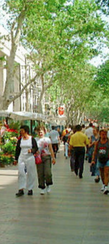 Figure[4]: Las Ramblas
The Las Ramblas is also one of the most important public space creations in the city. It is known as one of Barcelona's great boulevards known for great public spaces. It incorporates private operations in creation of public spaces in the city by attracting in private businesses including cafes, shops, and markets to the street. The Boulevard is about 1.5 kilometers long, consisting of a sixty feet wide central walk way lined with five to seven story buildings. Las Ramblas facilities social gathering by offering restricted, narrow lanes on either side of the central walk way for cars. Its prioritization of pedestrians created a remarkably viable community in the Gotic and El Raval neighborhoods. [4]
Although the Metropolitan General Plan was quite successful in efforts to regenerating the city of Barcelona, it faced criticism from both private land owners as well as the general public. Private land owners attacked the plan for devaluing their land and property as a result of dedicating them for public facilities. The general public and citizens also criticized the plan for the lacking of public involvement in the planning process. The plan was thought to be a private affair between the three people who generated it. [3]
Although the Metropolitan General Plan was quite successful in efforts to regenerating the city of Barcelona, it faced criticism from both private land owners as well as the general public. Private land owners attacked the plan for devaluing their land and property as a result of dedicating them for public facilities. The general public and citizens also criticized the plan for the lacking of public involvement in the planning process. The plan was thought to be a private affair between the three people who generated it. [3]
References
[1] Bollens, S. A. (2007). Cities, nationalism, and democratization. London: Routledge.
[2] Pacione, M. (1981). Urban Problems and Planning in the Developed World (Routledge Revivals). N.p.: Routledge.
[3] Marshall, T. (2004). Introduction and Urban Dynamics, Public Policies, and Governance. In Transforming Barcelona: The renewal of a European metropolis (pp. 4-43). London: Routledge.
[4] Nelson, P. (n.d.). Barcelona, Spain. Retrieved February 16, 2015, from http://depts.washington.edu/open2100/Resources/1_OpenSpaceSystems/Open_Space_Systems/BarcelonaCaseStudy.pdf
Media
[1] Plan Comarcal 1953 [Web Photo]. Retrieved from http://blogs.lavanguardia.com/postbarcelona-shu/files/2013/06/PGM.jpg
[2] Autonomous University of Barcelona. [Web Photo]. Retrieved from https://buffalo-sa.terradotta.com/index.cfm?Program_ID=10033&FuseAction=Programs.ViewProgram
[3] The Moll de Fusta Port of Barcelona . [Web Photo]. Retrieved from http://www.barcelonaphotoblog.com/2006_05_01_archive.html
[4] Las Ramblas. [Web Photo]. Retrieved from
http://depts.washington.edu/open2100/Resources/1_OpenSpaceSystems/Open_Space_Systems/BarcelonaCaseStudy.pdf
